As soon as the amateur leaves the bay or river with whose features he is well acquainted and ventures to take his vessel along a coast unknown to him, he must provide himself with the necessary instruments for finding his way and make himself familiar with their use.
As the management of large yachts is not within the scope of this book, it will be unnecessary to treat here of navigation properly so called, that is, the art of guiding a vessel across broad seas, out of sight of land, by observation of the sun and stars and by dead reckoning. But we may remark that an educated man will find no difficulty in rapidly acquiring the art of navigation if he wishes to do so. It is the seamanship that will give him trouble; for to acquire that a long apprenticeship and considerable natural capacity are necessary.
For coasting purposes and for crossing narrow seas such as the Channel, and the North Sea, and even for a voyage to the Baltic, sextants, chronometers, and other instruments of navigation proper are not required, and the following is a complete list of all that is needed for the purpose of finding one's way. 1. The necessary charts. 2. A mariner's compass. 3. A parallel rule. 4. A pair of compasses or dividers. 5. A log ship and line. 6..A hand-lead and line. 7. One of the small nautical almanacs which give the tide tables for the principal harbours of Europe. Pearson's almanac, which only costs sixpence, is one of the best of these and, in addition to the tides, imparts a great deal of useful information.
CHARTS. Whatever method is employed for representing a portion of a globe on a plane surface, the result can only be approximately correct. Charts are drawn on what is known as Mercator's projection, which, though it greatly distorts the relative magnitudes, is the most convenient for purposes of navigation.
The parallels of latitude on the globe are everywhere equidistant. On the other hand, the meridians of longitude are furthest apart at the equator, and gradually approach till they meet at the poles.
In Mercator's chart the meridians of longitude are drawn parallel and equidistant. The distortion in the direction of longitude resulting from this projection is counterbalanced by distorting the latitude to a proportionate extent; that is, the parallels of latitude are drawn further apart as the poles are approached.
Thus, on a chart of the world, the polar regions are greatly magnified when compared to the regions near the equator; still, as the degrees of latitude and those of longitude are proportionately magnified, the general shape of any particular tract is preserved.
The reason why this projection is the most adapted for purposes of navigation is that it produces no errors of direction, that is, if one place is north-west of another, it appears so on a Mercator's chart.
It follows, from what-has been said, that one scale of miles will not serve for a chart; as the scale is ever varying. The method of overcoming this difficulty while measuring the distance from one place to another on the chart will now be explained.
On inspecting an ordinary chart it will be found that the top of it is true north the bottom true south.
Along the top and bottom are graduated parallels, which are divided into degrees and minutes, and which enable us to distinguish the longitude of any position on the chart.
So, too, on the right and left sides of the chart we find graduated meridians also divided into degrees and minutes and which enable us to measure the latitude of any position on the chart.
Now, as a degree or a minute of latitude is the same length everywhere, we can use these graduated meridians as scales of miles. Each degree is divided into sixty minutes. A minute or nautical mile is about one-sixth longer than an English mile.
But as Mercator's chart distorts the latitudes, each portion of the graduated meridians serves as a scale of miles only to that part of a chart immediately opposite to it, that is, on the same latitude. Consequently, to measure the distance between two places on the chart, for instance, Falmouth harbour in latitude 50ş and Madeira in latitude 30ş, we proceed as follows. The dividers are spread out till their points are over the two places on the chart. This distance is then measured off on the graduated meridian, by so placing the dividers on the scale that the mean latitude of the two places, that is, latitude 40ş, is marked on the graduated meridian exactly halfway between the two points of the dividers.
The graduated parallels cannot, of course, be used as scales of miles for purposes of measurement.
While measuring distances on the large scale charts used for coasting purposes it matters little what portion of the graduated meridians be used as a scale, for the error will be imperceptible. It is only while using what are known as general charts, which extend across many degrees of latitude, that a considerable error will result from not measuring from the mean latitude.
Compasses are generally designed on various portions of a chart. These compasses usually indicate the magnetic and not the true bearings. (See COMPASS).
Various abbreviations are used on charts wbich are generally explained in a corner of the chart itself. Thus the nature of the bottom is indicated by sft for soft, c. for coarse, h. for hard, etc., while buoys are marked R. for red, H.S. for horizontally striped.
The soundings in fathoms or feet are indicated by numbers, the depth being calculated at low water ordinary spring tides. Where shoals sometimes dry, their height above low water spring tides is given by underlined numerals.
Roman numerals on a chart give the hour of high water at that spot at the full and change of the moon.
The velocity of the tide in knots is also indicated and its direction shown by arrows.
The yachtsman should provide himself with large scale Admiralty charts; for these alone can guide him into those shallow intricate channels frequented by small coasters only, which he will be so often tempted to enter.
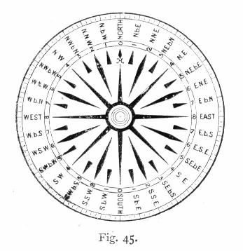
THE MARINER'S COMPASS.— Every one is more or less familiar with the use of the mariner's compass, the instrument which enables us to know the direction in which a vessel is sailing when out of sight of land.
The compass card (Fig. 45) is divided into thirty-two points, so, as a circle contains 360ş, the distance from one point to the next is 11Ľş.
Sometimes a point is expressed in its angular value, that is, the number of degrees the point is west or east of the meridional line joining north and south. Thus N. by E. would be called N. 11Ľ E., and N.E, N. 45ş E.
Compass bearings are calculated to quarter points, as N.E. Ľ E., which signifies N.E. and a quarter of a point towards E.
The compass card moves freely on a pivot in the compass bowl, which in its turn is balanced on gimbals, enabling it to preserve a horizontal position despite the vessel's rolling and pitching.
The binnacle or case in which the compass bowl is swung is provided with a lamp, so that the man steering can read the compass card by night.
Inside the bowl is a small mark, called the "lubber's line," which is exactly in a line with the head of the ship. That portion of the card which touches the lubber's line therefore indicates the direction in which the vessel is pointing.
The jerky motion of a small craft will often cause an ordinary compass card to oscillate and even to completely revolve, so that the direction in which one is steering cannot be ascertained. It is therefore necessary to use a heavy compass card whose movement will be more sluggish. A spirit compass — such as Dent's spirit compass — in which the card is surrounded by fluid — is the best adapted for small vessels.
But when a little craft is pitching quickly the very best compass will oscillate to some extent. In this case, one must observe the extreme points on either side reached by the swinging card and take the mean between them as the ship's direction.
The needle points to the magnetic north, which coincides with the true north in certain portions of the earth only. The difference between the magnetic and real north is called the variation of the compass, it differs in different places, and is constantly but very slowly changing.
The variation at the mouth of the Thames, for instance, is now roughly 20ş W., that is, the needle is dragged 20ş to the west of north, so that if a vessel's head be pointing true north, her compass will indicate a direction of about N.N.E.
The compasses designed on a chart generally show, as we have already explained, the magnetic and not the true bearings. Consequently, in order to ascertain the course that should be steered from one place to another, ue lay one edge of the parallel rules on the two places on the chart, and by opening the rule we slide the other edge along — always preserving the direction — until it is on the centre of one of the compass designs on the chart. The direction thus indicated represents the course to be steered by compass.
But if the compasses on the chart are, as sometimes happens, true and not magnetic, the course shown by the rule is not the one to be steered by compass. We must, in this case, discover the variation existing in the locality — generally given on the chart — and convert the true course as indicated by the edge of the rule into a compass or magnetic course. To do this, if the variation is so many degrees west, the course to be steered will be that number of degrees east of the true course; if the variation is so many degrees east, the course to be steered will be that number of degrees west of the true course.
Where there is local attraction, as in an iron ship, the compass bearings will not be correct magnetic, but the needle will be dragged on one side or the other of the magnetic meridian. This error is called the deviation of the compass.
On board a wooden yacht, if certain precautions are observed, there should be no perceptible deviation of the compass. As iron ballast is generally used on a yacht, the compass should be as high as possible above it. If the boat have a well, the binnacle can at least be on a level with the raised hatch on the deck.
Care must be taken that no elongated iron mass, especially if vertical, such as a bolt, be near the compass.
Deviation is not uniform, like variation. When the vessel's head is pointing about E. or W. the deviation is generally greatest, and it is different with every direction the vessel is turned to.
The deviation, if any, is ascertained by what is termed swinging the vessel. The correct magnetic bearing of some distant object is first obtained. The vessel is then slowly swung round — this can often be done by carrying the mooring line along one side of the deck aft, and then along the other side to the bows again — and as the vessel's head comes to each point of the compass, a compass bearing is taken of the object, and the difference between that bearing and the true magnetic one is noted.
A table can then be drawn out showing the deviation to be applied for each point of the compass towards which a vessel is steering.
When steering by compass, do not keep the eyes constantly fixed on the compass card, as this is extremely wearying, especially by night. When you have got the vessel on her course, get some object ahead — a distant vessel, a cloud, a star, if no land is in sight — in line with the mast, or one of the shrouds, and steer for that; referring only occasionally to the compass, so as to correct the direction and get a new mark to steer for when necessary.
THE LOG SHIP AND LINE are employed to calculate the speed at which a vessel is travelling through the water. The log ship (Fig. 46) is a quadrant-shaped piece of wood, loaded with lead at the bottom, so that it may preserve an upright position in the water. It is attached to the log line by means of a bridle.
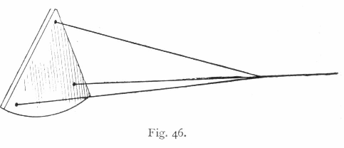
A bit of bunting is attached to the line about I2 fathoms from the log ship. These 12 fathoms are called the stray line.
The process known as "heaving the log" is performed as follows: One hand stands by, with the glass in hand, full end downwards; another hand heaves the log ship overboard, which floats away astern; the line is then steadily paid out from the reel, in such a way that no strain is put on the log ship.
At the moment when the piece of bunting marking the stray line goes overboard, the glass is smartly turned. As soon as the sand has run out, the man holding the glass calls out, "Stop!" and the log line is suddenly checked. The number of knots that have been reeled off represent the number of sea miles the vessel is sailing an hour.
Several forms of self-registering logs are now in general use. These are towed astern, and communicate the revolutions of a screw rotator to a register — either overboard or on the taffrail of the vessel — which indicates the distance run.
These patent logs do not act in an altogether satisfactory way on small sailing craft. They generally under log the distance run when the vessel is sailing slowly, and are more adapted for use on steamers. For ordinary cruising purposes, on a small fore-and-after, we prefer the old-fashioned log ship and line, and it is not very often that one has occasion to use even that.
THE LEAD LINE.— Two leads are employed on vessels — the deep sea lead weighing 28 lb., and the hand lead weighing 14 lb. The latter, or even a lead weighing somewhat less, is sufficient for a small yacht.
The line used for a hand lead is 25 fathoms long, and is generally marked as follows:—
| At |
2 3 5 7 10 13 15 17 20 |
fathoms " " " " " " " " |
Leather, with two ends. Leather, with three ends. White calico. Red bunting. Leather, with hole through it. Blue serge. White calico. Red bunting. Strand, with two knots in it. |
To sound when the vessel is under way, swing the lead round and throw it as far forward as possible, so that the lead be at the bottom and the line tight from it to the hand, when the vessel is just over the lead.
If the lead be hove properly, so that it draws the line through the hands, it is easy to tell when it has reached the bottom, by the sudden withdrawal of the strain.
When sailing on very shallow waters, soundings can be taken much quicker with a pole or boathook than with a lead.
There is a hollow at the heel of a lead which can be filled — armed as it is termed — with tallow; a specimen of the bottom — mud, sand, or shingle — is brought up with the lead, and this, by reference to the chart, which generally marks the nature of the bottom, may enable us to find our position.